Introduction

Welcome to my blog. The title originates when my primary athletic activity was competitive walking, but now that I am back to running it also includes that.

Not all content is accessible from the main page: for example, the rogaines, racewalking, and ultramarathon pages all include content that is only accessible from those pages.

Ultramarathons

Ultramarathons are any event longer than the standard marathon distance of 26.2 miles / 42.195km. Standard distances for ultras are 50km, 50 miles, 100km, and 100 miles. There are also 12 hour and 24 hour track runs, and multi-day "stage races".

I have currently (September 2012) completed 30 ultramarathons, plus 1 DNF at about 66km at the Molesworth Run. Reports for most events are provided below.

See also

Rogaines

Rogaining is the sport of long distance cross-country navigation. Events can be as short as 2-3 hours or the standard 24 hours. Teamwork, endurance, competition and an appreciation for the natural environment are features of the sport. Rogaining involves both route planning and navigation between checkpoints using a variety of map types.

GN Phillips and RJ Phillips, Rogaining, 3rd ed, 2000


The two main umbrella organisations for rogaining in New Zealand are: My reports for selected events are provided below.


Hiking and Mountains

The Hiking, Trail Running, and Mountains pages are all inter-related, but with some subtle differences:
  • Hiking is not an organised race, and may include Coastal Adventures, activities in the Mountains, and hiking in other locations;
  • Trail Running covers organised events, some in the mountains, but others on local hills and trails; and
  • The Mountains category covers both events and hiking in various places that can be classed as mountains.


  • Racewalking

    Racewalking only has to meet two technical requirements:
    • no loss of contact, as judged by the human eye; and
    • the leg has to be straight from the moment of first contact until it is upright.
    More detailed rules are here.

    I'm not particularly good at racewalking, often falling foul of the straight leg rule. But I still give it a go and here are the results of my endeavours.


    Running

    This blog is primarily about my walking activities, but sometimes I do run. Here are reports for events where I have run.

    Shorter Races

    I classify events as ultramarathons, marathons, rogaines, and "shorter events". So a "shorter event" is just something that is shorter than a marathon and is not a rogaine. Consequently there's a mixed bag in here: running, racewalking, half marathons, 10k and 5k races, , etc.


    Saturday, January 9, 2010

    Mt Hawtrey

    P1090020
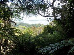
    View across flowering rata of the harbour entrance.
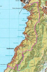
    There are two track systems in the northern part of the East Harbour Regional Park: the Mt Lowry tracks and the Butterfly Creek tracks. The relevant Regional Council publication shows these two systems connected by a "route" across Mt Hawtrey, and the "Vasque Extreme" edition of the Mt Lowry Challenge uses the same route. A traverse of the two track systems, taking in Mt Hawtrey, seemed in order...

    Map of East Harbour Regional Park
    Our route.
    Rather than starting at the northern-most point being the carpark on Wainuiomata Hill Rd, we decided to start at the next track south - the Howard Rd track. This gave us slightly more distance and, as we had discovered one week prior, the short additional section to the Hill Rd was not particularly inspiring.

    Up the Howard Rd track to the Main Ridge track and along to the Mt Lowry lookout. No deviation to the piece of pipe marking Mt Lowry this time. The track drops as it follows the main ridge to the Ferry Rd and Korimako Rd tracks.

    We were expecting the route across Mt Hawtrey to be a little difficult to find, so we were watching fairly carefully after the Korimako Rd track to find the turnoff. We were also expecting the Mt Hawtrey route to be nothing more than a route, with some markings and little in the way of a track. It turns out that there is a big sign post to announce the route, it is better marked than the Main Ridge track, the track is clearly visible, and it has a better surface than a lot of the Main Ridge track. What a con!

    P1090016
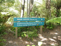
    The "route" was very clearly marked.
    P1090019
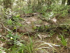
    The Mt Hawtrey marker peg.

    Mt Hawtrey (343m) turned out to be marked even more discretely than My Lowry (373m): instead of the metal pipe, this time there was a small wooden stake in the ground.

    Some steep descents at the end of the Mt Hawtrey route brought us out on to the Butterfly Creek track. We followed it in to the Butterfly Creek picnic area, ate our lunch, and then exited the Park via the (southern-most) Bus Barn track.

    0 comments:

    Post a Comment