Introduction

Welcome to my blog. The title originates when my primary athletic activity was competitive walking, but now that I am back to running it also includes that.

Not all content is accessible from the main page: for example, the rogaines, racewalking, and ultramarathon pages all include content that is only accessible from those pages.

Ultramarathons

Ultramarathons are any event longer than the standard marathon distance of 26.2 miles / 42.195km. Standard distances for ultras are 50km, 50 miles, 100km, and 100 miles. There are also 12 hour and 24 hour track runs, and multi-day "stage races".

I have currently (September 2012) completed 30 ultramarathons, plus 1 DNF at about 66km at the Molesworth Run. Reports for most events are provided below.

See also

Rogaines

Rogaining is the sport of long distance cross-country navigation. Events can be as short as 2-3 hours or the standard 24 hours. Teamwork, endurance, competition and an appreciation for the natural environment are features of the sport. Rogaining involves both route planning and navigation between checkpoints using a variety of map types.

GN Phillips and RJ Phillips, Rogaining, 3rd ed, 2000


The two main umbrella organisations for rogaining in New Zealand are: My reports for selected events are provided below.


Hiking and Mountains

The Hiking, Trail Running, and Mountains pages are all inter-related, but with some subtle differences:
  • Hiking is not an organised race, and may include Coastal Adventures, activities in the Mountains, and hiking in other locations;
  • Trail Running covers organised events, some in the mountains, but others on local hills and trails; and
  • The Mountains category covers both events and hiking in various places that can be classed as mountains.


  • Racewalking

    Racewalking only has to meet two technical requirements:
    • no loss of contact, as judged by the human eye; and
    • the leg has to be straight from the moment of first contact until it is upright.
    More detailed rules are here.

    I'm not particularly good at racewalking, often falling foul of the straight leg rule. But I still give it a go and here are the results of my endeavours.


    Running

    This blog is primarily about my walking activities, but sometimes I do run. Here are reports for events where I have run.

    Shorter Races

    I classify events as ultramarathons, marathons, rogaines, and "shorter events". So a "shorter event" is just something that is shorter than a marathon and is not a rogaine. Consequently there's a mixed bag in here: running, racewalking, half marathons, 10k and 5k races, , etc.


    Saturday, March 6, 2010

    Mt Tongariro Summit and West Ridge

    P3060158
    Having been up on Mt Tongariro several times we decided that it was time to actually visit the summit. And rather than doing the out-and-back along the tourist circuit we decided to go up the old Devil's Staircase route and head back down the west ridge.

    With a stroke of good luck we arrived at the carpark between bus loads of tourist - the previous load was well up the track, and the next load were faffing about getting ready to start. We made the most of the gap and set out along the Mangatepopo track, enjoying having it mostly to ourselves. At the end of the valley there was a large queue at the toilets at the bottom of the old Devil's Staircase and the new Nana's Rise.

    P3060080
    The route up the Devil's Staircase: somewhat less
    obvious with the poles gone.
    We took a quick detour off to see the small waterfall at Soda Springs, and then set off up the Devil's Staircase. DOC has removed all poles and track markers from the Devil's Staircase. This was not a problem lower down, as the track remains very clear. But higher up the route became a lot less obvious so it was mainly a case of picking what looked to be a likely route up. Having strayed a little to the right we topped out slightly east of where the old route would have come out.

    P3060102
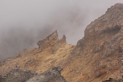
    Rock formations near the first summit.
    Near the signposted turn off to Ngauruhoe we stopped for a Gu, and then we joined the throngs heading across South Crater and up the crater rim. A few people were having "anxious moments" climbing the rim, providing an opportunity for a breather. We took the sign posted turn off to the Tongariro summit, and soon found ourselves in patches of cloud. Far below us to our right we could see the floor of Central Crater and, occasionally, Blue Lake. Off to our left we could see a spur and a gully that looked like a viable alternative route up from South Crater.

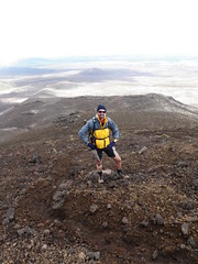
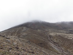
    As we neared the first summit the wind picked up significantly. Stopped for a brief photo at the summit cairn and then on to the main summit, officially just 6m higher. There was no cairn at the main summit: a large rock stood in its place. A brief attempt to sit on the summit by me, and then off a short distance to find a place out of the wind to have lunch.

    P3060122
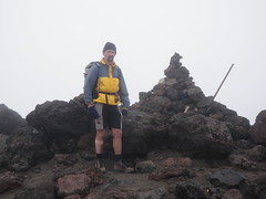
    At the first (low) summit.
    P3060127
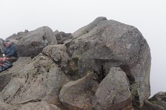
    The summit rocks at the second, slightly higher, summit.

    Cloud parted occasionally to give a brief glimpse down the Wanganui River valley, but there were few clues as to where we would be heading. Although very rocky, travel was easy as we set off in the direction indicated by the waypoint programmed into my GPS.Every so often we would see a footprint heading in the same direction, so we knew at least someone else had been in this direction. Progress slowed for a while as the GPS bearing jumped around a bit, but we were still heading down and in the right general direction.

    143-145 panorama
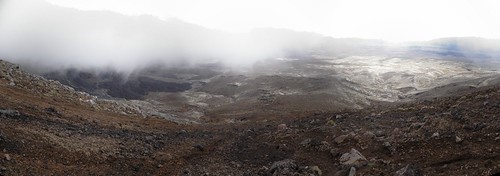
    Mangatepopo Valley to the left; Wanganui River Valley to the right. We were heading down the ridge between the two valleys.

    P3060182
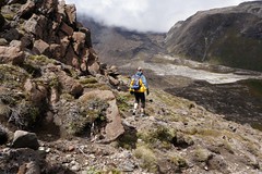
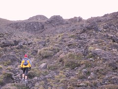
    One of the less obvious sections of track, but great views.
    As the cloud started to clear we saw glimpses of the cliffs ahead, with our intended route along the top. As we dropped further a track was apparent across the top of the cliffs, so clearly plenty of people had been here before us. The track was initially very clear, but then became intermittent.

    P3060213
    The start of the vegetation.
    Vegetation started to appear in between the rocks and progressively became taller and thicker, with tussock giving way to heather, hebe, and other scrub. As the track became obscured by the scrub it also developed large holes and ruts, and on several occasions I fell over as I suddenly dropped into a large ditch-like section of the track. Eventually we made it down to the first of the fast-flowing streams and pushed our way up the other side into more scrub. One more stream, more difficult to cross than before, and the vegetation on the other side was shoulder high. Just a short further push and we were finally back at the carpark.

    P3060166
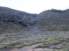
    View back along the ridge where we descended from
    Tongariro, also showing the stream we intend to use
    as an exit route "next time".


    P3060070
    Where the stream comes out by the Mangatepopo Track.
    We're already planning "next time": next time we will:
    • go up the Devil's Staircase again, but try and get the correct line (further to the left) towards the top;
    • head in a more northerly direction across South Crater and climb the spur to the crater rim;
    • sidle around to the saddle between Tongariro summit and North Crater, and from there pay a visit to North Crater;
    • sidle back around to the west side of Tongariro summit from North Crater, and start our descent the same way we did this time; and
    • avoid the bush bashing on the way back by dropping down to the Mangetepopo track at somewhere near the soda springs.

    More photos are available on Flickr.

    0 comments:

    Post a Comment