The day before I set up waypoints for my GPS, based solely on what looked like a good route from the topo map. But the topo map doesn't mark lava flows, and it doesn't mark vegetation. The latter in particular would come back to bite us at the end of the day.
After logging our intentions at the Mangatepopo hut we backtracked just a few metres back towards the carpark, where an obvious well-trod route led from the main track towards the base of Pukekaikiore. Travel along here was straightforward: the route was, for the most part, easily visible, and we gained height at a steady rate.
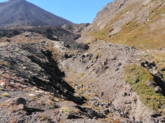
The first surprise came as a very obvious and well used section of track ended abruptly against the end of a flow of black scoria. It was far from obvious where the "correct" route was, so we elected to just head forwards through the scoria. Out the other end we regained the track, although it was often less distinct than before.
We were soon at the end of another scoria flow, with the choice of going either right along the boundary between the scoria and Pukekaikiore, or left up a clear "lane" between two flows. Reasoning that the clear lane would be easier travel than clambering over scoria and rocks, we elected to go left. It soon became apparent that we had made the wrong choice, as the lane came to a dead end and we had to pick our way across the scoria back to a clear area beside Pukekaikiore.
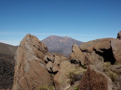
Another flow of black scoria butted up against Pukekaikiore just ahead, and this time there was a very obvious path. Out into another clearing and there was just one more flow of scoria that marked the saddle between Pukekaikiore and Ngaruhoe. The path climbed the side of Pukekaikiore to the saddle. There were spectacular views of Ruapehu from the saddle, and we could also look down and see the significant height that we would lose as we made our way around to the foot of the southern ridge.
A steep descent down the side of the scoria flow and then a largely flat walk around to the bottom of the south ridge. We stopped for lunch at the bottom of the ridge and then started the long walk up. There is nothing technically challenging about the ridge, it was just a long walk regaining a lot of height we had recently lost, and doing it in the hot sun.
The summit area is a reasonably flat plateau and it is difficult to pick up precisely where is the highest point. There were great views all around: Tongariro, Ngaruhoe, Ruapehu, and the plains to the west.
Having taken summit photos and had a bit of a breather it was time to head down. Heading for the first waypoint to the west we found ourselves walking down some steep slopes of soft, but reasonably well compacted, volanic sand and small scoria. This was easy travel and a welcome alternative to the slog up.
After a while we reached the scrub line, with vegetation reaching up to our knees. My pre-set waypoints had us heading down the dry stream, but for some reason we instead decided to go cross country in a direct line for the Mangatepopo Hut. Big Mistake! The scrub got higher: waist, shoulders, and then over our heads. It formed a dense and at times seemingly impenetrable screen. At its thickest it took us 43 minutes to travel just 430m! The hillside was steep so it was much easier to use gravity to help us go down rather than fighting back up to see if there was an easier way. Somewhere in there Jan lost her rainjacket off the back of her camelbak.
Finally we were out and it was an easy walk back to the hut to record that we were out, and then back to the car.
More photos available on Flickr.


0 comments:
Post a Comment