It's that time of the year for Kepler training, so I took Heather for a trip around the
Ultra Fun Run short circuit. The weather was supposed to clear, but it ended up being cold, grey, and very windy up on top of Mt Climie.
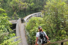
Descending past the Birchville Dam
Our plan was to run parts of the circuit, although neither of us felt like running a great deal. 46:59 to the top of Cannon Point, so in line with what I had done previously. Down via the Birchville Dam rather than the steep bush track, then up the river and out to Te Marua. Around behind the water supply lakes and up to the SH2 underpass. Reached the gate at Kaitoke loop road in 2:37:58.
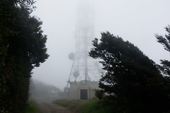
The first transmitter tower emerges in the wind-
blown clouds.
Down to Tunnel Gully and tagged the gate on the Mt Clime access road in 3:01:53 (3:04:45 previous best). From there things started to unravel a little as Heather discovered just how tough the long ascent can be with 77:21 to the top. At the top it was cold and windy, and we were in the clouds, so we both changed into some warmer layers, rain jacket, and hat/gloves.
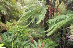
Part of the route off Mt Climie. No track particularly
discernable, but there is a clear route through the
vegetation.
The descent was a little slippery, requiring slower going in some places. We reached the road 79:05 after leaving the top. A quick refill of water at Mangaroa School and we walked most of the rest of the way home for a total time of 6:41:30.
0 comments:
Post a Comment