Introduction

Welcome to my blog. The title originates when my primary athletic activity was competitive walking, but now that I am back to running it also includes that.

Not all content is accessible from the main page: for example, the rogaines, racewalking, and ultramarathon pages all include content that is only accessible from those pages.

Ultramarathons

Ultramarathons are any event longer than the standard marathon distance of 26.2 miles / 42.195km. Standard distances for ultras are 50km, 50 miles, 100km, and 100 miles. There are also 12 hour and 24 hour track runs, and multi-day "stage races".

I have currently (September 2012) completed 30 ultramarathons, plus 1 DNF at about 66km at the Molesworth Run. Reports for most events are provided below.

See also

Rogaines

Rogaining is the sport of long distance cross-country navigation. Events can be as short as 2-3 hours or the standard 24 hours. Teamwork, endurance, competition and an appreciation for the natural environment are features of the sport. Rogaining involves both route planning and navigation between checkpoints using a variety of map types.

GN Phillips and RJ Phillips, Rogaining, 3rd ed, 2000


The two main umbrella organisations for rogaining in New Zealand are: My reports for selected events are provided below.


Hiking and Mountains

The Hiking, Trail Running, and Mountains pages are all inter-related, but with some subtle differences:
  • Hiking is not an organised race, and may include Coastal Adventures, activities in the Mountains, and hiking in other locations;
  • Trail Running covers organised events, some in the mountains, but others on local hills and trails; and
  • The Mountains category covers both events and hiking in various places that can be classed as mountains.


  • Racewalking

    Racewalking only has to meet two technical requirements:
    • no loss of contact, as judged by the human eye; and
    • the leg has to be straight from the moment of first contact until it is upright.
    More detailed rules are here.

    I'm not particularly good at racewalking, often falling foul of the straight leg rule. But I still give it a go and here are the results of my endeavours.


    Running

    This blog is primarily about my walking activities, but sometimes I do run. Here are reports for events where I have run.

    Shorter Races

    I classify events as ultramarathons, marathons, rogaines, and "shorter events". So a "shorter event" is just something that is shorter than a marathon and is not a rogaine. Consequently there's a mixed bag in here: running, racewalking, half marathons, 10k and 5k races, , etc.


    Showing posts with label Mokihinui. Show all posts
    Showing posts with label Mokihinui. Show all posts

    Monday, October 22, 2012

    Seddonville Falls

    A prominent feature in Seddonville is a 7m high waterfall. There's no easy way to get to it, but a local gave me directions to get to the top. First, take the single lane gravel road opposite Hope Street. He assured me that this is a legal road, and a check online reveals that at least the first part of it is on road reserve: it is part of the reserve for Hope Street. This section of road zigzags up the hill. From the top of the hill walk across towards the waterfall: first across a paddock, and then through bush. Once in the bush it was obvious that others had been here before, although not tracked or marked. I emerged out right at the top of the falls, and had the view below.

    The falls as seen from the road.
    View from the top of the falls.

    Friday, October 19, 2012

    Trig F (Mokihinui)

    Just a short 1km walk from the Seddonville Motorcamp, being in the area it was too good to pass up!

    Officially given the code A5CX, the Geoditic Databse says that this survey mark is "Not beaconed"! I shall forward the photos to LINZ and get that entry rectified.

    Right: Trig F with Mt Glasgow behind.
    Below left: View along Mokihinui Rd towards Mt Glasgow.
    Below right: View back down Mokihinui Rd towards Seddonville.

    Sunday, October 23, 2011

    Seddonville

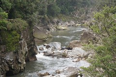
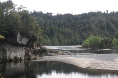
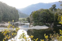
    The Mokihinui Valley should perhaps be called the Valley of Unrequited Dreams: the river sparkles with Fools' Gold, and at the right time of year there is an influx of whitebaiters hoping to catch the delicacy that sells for over $100/kg in North Island shops. The old timers will tell you of days past when the "spotters" in the river used to go black as the huge shoals of whitebait swum past, but those days are long gone.

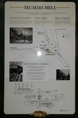
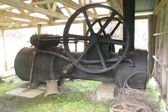
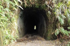
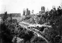
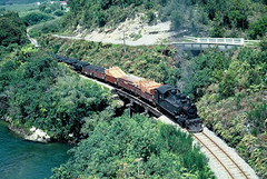
    At the head of the valley lies the township of Seddonville, once the base for logging and coal mining operations. Coal mining was centred particularly around Chasm Creek, Coal Creek, and Charming Creek - the latter being one of the longest lived mines in New Zealand.1 Even those activities have an element of unrequited dreams: Seddonville was the site of the first state-owned coal mine in 1893, but that struggled and closed after just 21 years; and private mining ceased in the 1990s as the high sulphur coal became difficult to sell.2

    Grader
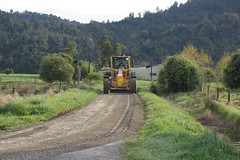
    The Grader works on one of the side streets
    Nowdays Seddonville no longer has any particular reason for continued existence, and like many small New Zealand settlements continues to exist solely because it was established at some point in history when there was more work to be done.

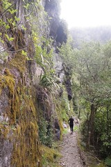
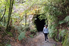
    At the end of a side road that leads up the valley from the main road through to Karamea, the main reasons for visiting Seddonville would seem to be to walk the 
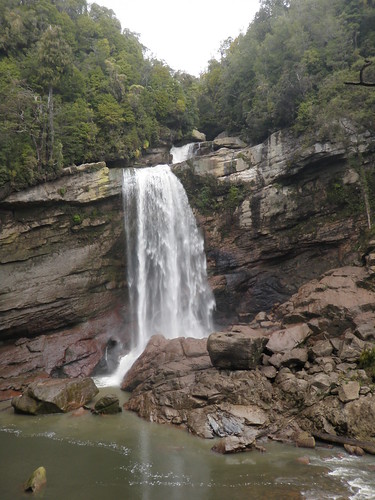
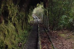
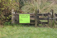
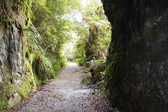
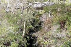
Chasm Creek walkway, walk the Charming Creek walkway, or to fish for whitebait when it is in season. The Mokihinui is a good river for trout fishing, but will never draw the same numbers as flock to the Tongariro River and Lake Taupo.
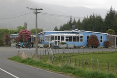
    Seddonville Hotel
    Seddonville Hotel
    Any visitors must surely visit the Seddonville Hotel, which is also the local cafe, restaurant, dairy, and motels. We never sampled the fair from the cafe, but the meals were very good, and the newly refurbushed motels were excellent. It also appears to be a place to visit in its own right - three middle aged motorcyclists were observed arriving, then after some refreshments tinkering with their bikes for about half an hour or so before riding back out to the main road.

    A testament to more prosperous and populous times, the old school has been converted into a Holiday Park. Rates are reasonable, both for caravans and the (very tidy) bunk rooms. The toilets and showers are very clean, and the kitchen and common room are very welcoming. For my money, the Seddonville Holiday Park is a better standard than the larger holiday parks in more popular locations.

    Expensive View
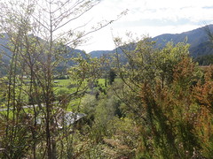
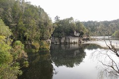
    View from the section
    Just past the old school, where Gladstone Street becomes Charming Creek Road, an unsealed driveway climbs steeply up a low hill to a 1 acre section. At the top of the driveway is a decrepit old caravan and piles of old wood, iron, and other assorted items. The driveway turns left into a flat site, cleared a year ago, but now being reclaimed by gorse. We are told that the section was bought 5 years ago by someone on Waiheke Island who wanted to "live the dream", but is now being sold as the dream slips further away. There would be extensive views of the valley with a little bit of clearing, but the price was more than a little steep for a section with no utility services - no power or phone. The owner will be hoping for another gold rush perhaps!

    Regardless of the above, or more likely because of it, Seddonville is a remarkable place to visit. The pace of life slows and one can really relax. I hope to be back again in the not too far distant future.

    Notes:
    [1] New Zealand History online: Charming Creek
    [2] New Zealand History online: Seddonville

    Links:

    Friday, October 21, 2011

    Charming Creek

    OLYMPUS DIGITAL CAMERA
    The Charming Creek walkway follows an old tramline that was used for extracting coal and timber from the Charming Creek area. The northern end of the walkway starts at the old mine entrance. From there the track descends gently downhill to the Ngakawau River and then down through the Ngakawau Gorge to the coast.

    The Charming Creek end of the walkway has a number of old relics, including old boilers. The track passes another vertical boiler that has been painted to better preserve it, and then winds passed a large flat area that appears to have been the site of a coal stockpile. While isolated railway sleepers have appeared at odd intervals till this point, now there are several long straights with all the closely-spaced sleepers still in place.

    Mumms Mill Steam Engine
    Steam Engine at Mumm's Mill
    Mumm's Mill has the mill steam engine under cover, and informative story boards describing the operation of the mill. There are also a number of other relics in the area, including isolated sections of rail.

    Just before a small swing bridge is a small spring, leaching sulphur. This is apparently the site of a hole drilled during coal prospecting in the period 1910-1912. Across the bridge and the scenery becomes more spectacular as the old railway formation begins to wind its way through the Ngakawau Gorge.

    PA210385
    Mangatini Falls

    Mangatini Falls are first seen approaching a tunnel, then once through the tunnel again visible and more spectacular. A side track leads down to the river to provide better views.

    OLYMPUS DIGITAL CAMERA
    Section of track showing wooden centre rail used
    for braking.
    OLYMPUS DIGITAL CAMERA
    Ngakawau Gorge
    OLYMPUS DIGITAL CAMERA
    The track remains largely intact along this section, including a wooden centre rail which would have been used for braking to slow heavy coal trains as they descended through the gorge. The track then crosses a swing bridge before edging its way along the bottom of some sheer rock walls (marked with signs pointing out the danger of falling rocks).
    Ngakawau River mouth
    View of Ngakawau River mouth
    Finally down to "The Bins", which was also the site of a railway siding. Near here are views down towards the mouth of the Ngakawau River, including the road bridge for the road north.

    The posted time for the walkway is 3 hours on the DOC sign, but it took us about 1h45 with some running, some walking, stops for photos and to admire the views, and stops to read the information boards.

    Plan from 1912 showing coal at Charming Creek
    Plan showing coal at Charming Creek. Source (with explanatory text): New Zealand History online

    Links:

    Thursday, October 20, 2011

    Chasm Creek Walkway

    Mokihinui River
    The Chasm Creek walkway takes in a very scenic part of the old Ngakawau-Seddonville railway, just a few hundred metres west of Seddonville. The walkway itself is perhaps only 500m long, so we tacked it on to the end of a morning run from the Seddonville Holiday Park and through the streets of Seddonville. These photos show some of the highlights - the main river is the Mokihinui River, and this section is simply stunning.

    OLYMPUS DIGITAL CAMERA
    Mokihinui River

    Tunnel
    Tunnel View

    Mokhinui River
    Tunnel


    Road and Rail Bridges

    Road Bridge
    View of the road bridge from the old Chasm Creek rail bridge
    chasm-creek-train F166 1903
    chasm-creek-train Ww571 1968
    Photographer Henry Winkelmann captured this
    'mixed train' (featuring both freight and passenger
    carriages) crossing Chasm Creek bridge in 1903.
    The locomotive is an F class (possibly F 166).
    Source: Train crossing Chasm Creek bridge, 1903
    Headed by Ww571, a freight train carrying timber
    and coal crosses Chasm Creek bridge in December
    1968. Photographer: Graeme McClare, 1968
    Source: Train on Chasm Creek bridge, 1968
    Both photographs Ministry for Culture and Heritage, New Zealand History Online, updated 22-Feb-2009