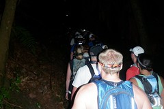
Starting in the dark
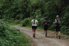
I soon caught up to Vivian Cheng. I would catch and pass her on the uphills, and then she would pass me again on the flat. A few photos, and soon after 5km Vivian moved off ahead. I thought I might see her later on the long climbs after the Miller Road aid station.
Heading towards Blue Lake I found myself alone on a nice section of single track through the bush. Course markings were few and far between along here and I wasn’t always entirely confident that I was on the right track. Not long before the track came out at Blue Lake I was caught by Belinda Archer. We were both glad of the reassurance that someone else was heading in the same direction! It turned out this was Belinda’s first 100km event, having decided to do this in preference to TNF100 in Sydney. In retrospect there wasn’t actually anywhere to go wrong along this section, but that would soon change...
A short distance along the Blue Lake track and we reached an unmarked major intersection. Down and to the left towards the lake, or up and to the right? We went right for 100m or so, and still not having seen a marker went back to the intersection and tried the other track. Perhaps 300m along that track split into three branches, and none of those had course markers either! So it was back to the intersection and back on to the uphill track again.
Heather, Norman and Belinda
Coming out of the aid station I somehow made some time on all three, but they all caught back up again as we stopped to ponder another unmarked intersection. This time the reasoning of “stay close to the lake” proved correct.
The trail popped out on to the road and along to Lake Okareka. Again I got ahead on the uphill, but was caught and passed on the downhill. Belinda, Heather, and Norman checked into the aid station before me, but the girls went off to use the toilets and I had left before they re-emerged.
A short distance up the road the surface turned to gravel (yay!) and then came another aid station marking the start of the Western Okataina Walkway (Millar Road). It was 18km to the next aid station at Okataina Lodge, so I made sure I stocked up. A drink of coke, a drink of water, top my bottles up, a banana, some Ems cookie, and a few jellybeans.
The Western Okataina Walkway started innocuously enough, and much of it seemed to be a good surface for walking, but it was deceptively brutal. My memory is of long climbs, and very few flat areas for respite.
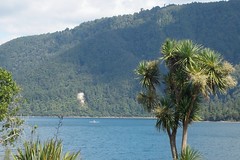
Lake Okataina
On to the Eastern Okataina Walkway. What was Richard on about? This was a lovely trail.... but then came a hill, a big hill, then a few more undulations, and when the trail flattened out it was a little more technical with roots and rocks. Up another climb, drop down into a fairly narrow chasm, then out to the lake shore again. This was the Humphries Bay aid station, 48km, on the shores of Lake Tarawera.
I stocked up on drink and supplies then on my way again. The track goes inland a short way from the lake for a while. When it comes back out to the lake there is a sheer rock wall to the left and I lost the GPS signal. From memory this was pretty much flat, just a little technical with rocks and roots once one was already tired. I can’t remember too much about this section, so I must have been fairly tired.
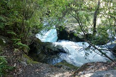
At some point we reached Tarawera Outlet and from there we had the noise of the river running close to the track. The surface generally seemed to be good along this section, and the river was a welcome distraction. I stopped to take a photo of a small set of falls, shining brightly in the sun. A bit further down the track was the main set of falls – spectacular – but my camera battery died!
Tarawera River
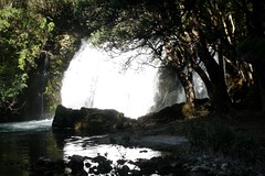
The low falls
Across the 60km finish in 9h55, some 2 hours slower than I thought I might be. Stopped to regroup, refuel, and talk to Mick Finn who had decided to call it a day rather than carry on for the 100km. As I was there a couple more people came through, including Michelle Dickinson and Michael Cartwright.
Michael is most recently from Seattle and was over here on holiday with his wife Tamara, a vacation conveniently timed so that they could both run Tarawera. I had only met Michael a few days earlier but it was good to have a familiar face to continue on with. We set off along the forestry road. Although wide, arid, and dusty, it was also nice and flat, so it seemed like travel would be straight forward.
A sharp turn right on to a side road and soon we were on a long, long hill. Four runners – two wearing yellow and two wearing red – were walking up ahead. I dropped Michael and managed to catch and pass all four runners. After we finally got to the top of the hill the runners in red caught and passed me, but I never saw the two runners in yellow again.
Michael caught up again some way down the road, and then ran on ahead. I then caught up when he stopped to walk, and then I would edge ahead. We left the Titoki aid station together. Signs on the road indicated turn right for the long course (100km) and left for the “short course”. We were just here for the short course so we turned left. More sections of forestry road, but also some single track beside the river – through ferns under a canopy of pine. On to another forestry road that felt like a long straight avenue, and then the Fisherman’s Bridge (70km) aid station. Michael was ahead of me by this point, and was already heading out as I was just arriving.
A quick chat to the RD Paul Charteris, a few moments to catch my breath, drink, and eat, and then I was off again. A very nice, little used road along this section. The light was starting to fade.
I caught Michael with about 8km to go (so probably at around 78km) – I couldn’t be sure of the exact distance as my GPS had run out of juice, and this last section would be done without any electronic feedback as to time or distance. It sounded like Michael’s legs were toasted and he was planning on walking the remaining distance to the finish. I kept on going and soon it was sufficiently dark that I could no longer avoid getting my light out.

The Finish
Photo: Richard Wall
Photo: Richard Wall
More photos available on Flickr.
5 comments:
Nice report Andrew ... you are an amazing walker.
Great writeup, I don't know how you remember so much detail, it all such a blur in my brain now. Must be time to do another one so I can remember :)
Great writeup. I'm hoping to make it this year and wondered about hills on this trail. Your report has helped confirm that my training which includes long elevation climbs (walking!) is valuable.
Are you there this year Andrew?
Hi Paul,
I'm "sort of" there this year... I'm supporting someone else for the first 60km and then join in as pacer until the end of the 85km. Looking forward to it, it's great fun watching other people race, I'll get to see many more people that I know throughout the day, and I still get to join in at the end!
I'll see you there!
www.robotoranges.com
Post a Comment